27 Oregon Waterfall Hikes That’ll Leave You Gobsmacked!
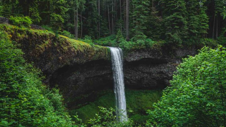
If there’s one thing Oregon has a lot of, it’s hiking trails. Each has its own unique reward, be it epic landscapes, towering mountains, rugged coastlines, or, my favorite, waterfalls. There are SO many waterfall hikes in Oregon!
Chasing waterfalls is kind of a hobby of mine, and there couldn’t be a better state to indulge in this minor obsession.
So, which are our favorite waterfall hikes in Oregon? Uhm… a lot!
The Best Waterfall Hikes in Oregon
Below, you’ll find tons of our favorite Oregon waterfall hikes, plus all of the necessary hiking info to help you explore better. We also made a handy map here for you to use to best see where all of these hikes are.
We’ve done every waterfall hike on this list and can tell you, yes, these are truly the best ones in the state!

✋ HOLD UP! Don’t Forget…
You need some wheels! It’s nearly impossible to get around the USA and check out the best adventures without a car! Here are our top recommendations…
🚗 Rent a car
If you don’t have your own, renting a car is your best bet!
🚐 Rent a home on wheels
For the more adventurous, rent a van or RV and ditch the hotel.
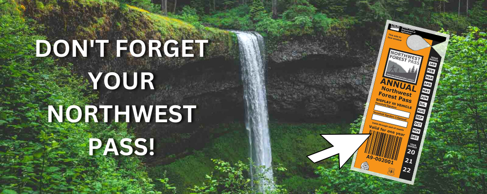
Don’t Forget This!
A lot of the best adventures around Oregon will require a Northwest Pass. You can easily get one delivered straight to your door. Grab it now before you leave!
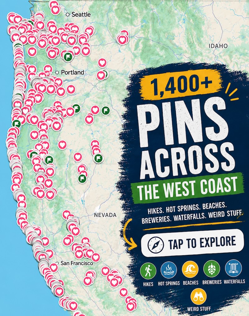
📍 GET THE ULTIMATE PNW MAP 🗺️
Get our curated list of the best adventures, things to do, and places to grab a brew loaded onto your maps with just two clicks!
✅ Waterfalls ✅ Hikes ✅ Viewpoints
✅ Craft breweries ✅ National Parks ✅ 1400+ Pins


Waterfall Hikes Near Portland
As the largest city in the state, Portland is a must-visit for restaurants and nightlife. But it’s also home to some incredible green spaces, lakes and rivers that make it a great choice for outdoor types.
Just beyond the city limits, you’ll find even more to explore, including these hikes to waterfalls.
More guides:
- 43 Best Things To Do in Portland
- 17 Best Beaches in Portland
- 13 Portland Tours
1. Wahkeena-Multnomah Loop
Distance: 5.1 miles
Type of Trail: Loop
Difficulty: Moderate
Elevation Gain: 1,640 ft
Other important info:
- Dogs are allowed
- There is no fee for this trail
- A $2 timed use permit is required to hike Multnomah Falls between Memorial Day and Labor Day
This hike is a serious waterfall lovers’ paradise, and for a moderate hike, it is hard to beat this one. Overall there are six main waterfalls on this trip, as well as plenty of other smaller falls along the route.


The loop can be hiked in either direction, either at the Wahkeena Falls or Multnomah Falls trailhead. However, if you want to avoid most of the crowds and get out of the way from the beginning, start at Multnomah Falls.
The initial climb with 11 switchbacks will be worth it when you hit the Multnomah Falls Viewpoint. From here, continue on the Larch Mountain Trail, where a series of smaller waterfalls will greet you.

As you begin to reach the end of the hike, the trail starts to switch back downhill to the base of Wahkeena Falls, offering beautiful views up the creek.
→ If you are traveling alone, join this awesome waterfall hiking tour to the Columbia River Gorge from Portland...
READ MORE: Wahkeena Falls
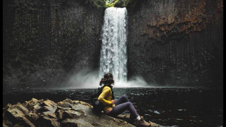
2. Abiqua Falls
Distance: 0.7 miles
Type of Trail: Out & Back
Difficulty: Moderate
Elevation Gain: 249 ft
Other important info:
- Dogs are allowed
- There is no fee for this trail
- The road to the trailhead is a bit rough—high-clearance vehicles are recommended! Otherwise, park further back and walk in.
The Oregon waterfall hike to Abiqua Falls is short and sweet, yet the end result is one of Oregon’s most scenic waterfalls. The trail itself may take a little finding and is not very well marked.
From the parking lot, head back down the dirt road until you reach the forest.


Follow the dirt path down to the creek, using the handily placed rope at the steeper parts, and simply follow it upstream until you get to the falls.
When you get a little closer to the tumbling water, be prepared to clamber over a few logs and boulders, but you will soon come across the 92-foot-tall waterfall that freefalls down into the pool below.
READ MORE: Abiqua Falls Hike
3. Tamanawas Falls Trail
Distance: 3.4 miles
Type of Trail: Out & back
Difficulty: Easy
Elevation Gain: 580 ft
Other important info:
- Dogs are allowed
- There is a fee for this trail, pay $5 or display your NW Forest Pass
- Seasonal road closures may occur, weather depending
The broad curtain of water that is Tamanawas Falls is formed by Cold Spring Creek thundering over a 110-foot lava cliff near Mount Hood, and the results are pretty impressive.
Start at the Tamanawas Falls Trailhead and head through the forest, which is covered in wildflowers in spring and summer. The trail steadily climbs, passing smaller waterfalls, a boulder field, and some switchbacks before reaching the main event.


You can then follow one of the well-used trails to get a closer look. If you’re up for it, continue hiking along the right side to walk behind the falls.
TIP: With the right gear, this Oregon waterfall hike can be enjoyed at any time of year, and in the winter, the water freezes over, creating a massive icy amphitheater.
READ MORE: Tamanawas Falls Trail
🏨 Need a place to crash nearby?
From rustic cabins to boutique inns—check prices and availability in just a click.
4. Latourell Falls
Distance: 2.0 miles
Type of Trail: Loop
Difficulty: Moderate
Elevation Gain: 639 ft
Other important info:
- Dogs are allowed
- There is no fee for this trail
- Trail is currently closed for construction, check here for updates
Latourell Falls is a popular hike for several reasons. Firstly, it is incredibly photogenic, and second, it is one of the closest Oregon waterfall hikes to Portland.
The falls themselves are a 224-foot single plunge, and this hike will also take you to see the two-tiered Upper Latourell Falls.


Start at the Latourell Falls Trailhead and follow the paved path to the first viewpoint. You can then take the wide dirt path upwards and check out a side view of the falls.
Follow the trail to Upper Latourell Falls, and the trail will cross the creek at the base of the falls, offering a great viewpoint before heading back down the west side of the stream.
→ For a fun and active tour to Latourell Falls and other beautiful falls in the Columbia River Gorge, take this hike and bike waterfall tour from Portland.
RELATED: Columbia River Gorge Hikes
5. Horsetail Falls and Ponytail Falls
Distance: 0.8 miles
Type of Trail: Out & Back
Difficulty: Easy
Elevation Gain: 301 ft
Other important info:
- Dogs are allowed
- There is no fee for this trail
Situated in the Columbia River Gorge, both Horsetail and Ponytail Falls can be enjoyed on this Oregon waterfall hike. Both falls are glistening streams of water down the rock, with Horsetail towering at 176 feet and Ponytail at 125 feet.

The trail begins at Horsetail Falls and immediately begins climbing up a series of switchbacks. It isn’t long before you come across the smaller Ponytail Falls, with the trail passing right behind the waterfall.

The trail then continues level for a while before you begin to make your way down, all the while being incredibly scenic, with stunning views of Oneonta Creek and Oneonta Gorge.
You will also get a glimpse of some other falls along this route, including Middle and Lower Oneonta Falls.
RELATED: Hikes Near Portland
6. Tunnel Falls via Eagle Creek Trail
Distance: 12.2 miles
Type of Trail: Out & Back
Difficulty: Hard
Elevation Gain: 2,142 ft
Other important info:
- Dogs are allowed
- There is a fee for this trail, pay $5 or display your NW Forest Pass
- Road to trailhead is subject to seasonal closures
This Oregon waterfall hike will make you work for the views, but you won’t mind the challenge once you’re in front of Tunnel Falls.

Actually, you don’t even have to wait that long for the payout—there are several waterfalls along this route, including Punchbowl Falls, Loowit Falls, Metlako Falls, and many more.
The climb is steep, but there are plenty of places to stop along the way for a picnic or a scenic sip of water. If you’re up for a bigger challenge, continue on Eagle Creek Trail for a multi-day backpacking excursion (permit required).
7. The Trail of Ten Falls
Distance: 7.4 miles
Type of Trail: Loop
Difficulty: Moderate
Elevation Gain: 1,181 ft
Other important info:
- Dogs are not allowed
- There is a fee for this trail, pay $5 or display your Oregon State Park Parking Permit
It would be crazy not to include Silver Falls State Park on this list because it’s only about an hour away from Portland. Oh, and it’s STUNNING.
The Trail of Ten Falls is undoubtedly one of the best waterfall hikes in Oregon. To make the trek even more magical, you can walk behind four of the ten waterfalls—a rare privilege.


Read our guide to Silver Falls State Park for how to best see this trail.
→ If you don’t have access to a vehicle, join this fun day trip from Portland to hike the Trail of Ten Falls Loop at Silver Falls State Park and visit a local winery
READ MORE: Silver Falls State Park
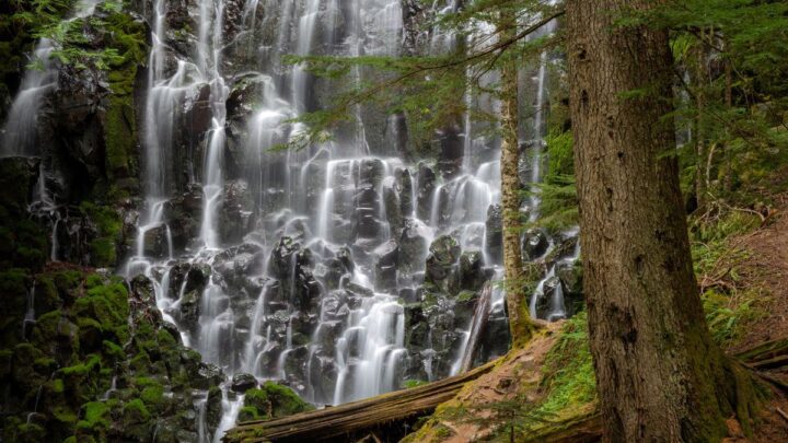
8. Ramona Falls
Distance: 7.1 miles
Type of Trail: Loop
Difficulty: Moderate
Elevation Gain: 1,046 ft
Other important info:
- Dogs are allowed
- There is a fee for this trail, pay $5 or display your NW Forest Pass
- Wilderness permit required to hike between May 15 and October 15
Ramona Falls is a must-visit waterfall in Oregon, and it’s one of the best hikes in Mount Hood.
The waterfall is situated on the Sandy River and is accessible via a moderately challenging hike through the forest. The trail passes through old-growth forests and offers beautiful views of Mount Hood and the surrounding wilderness.

But the highlight of the hike is the 120-foot waterfall, which cascades down a mossy basalt cliff.
Along the way, hikers may also spot wildlife such as deer and birds. The trail is open year-round, but the best time to visit is during the spring and summer when the weather is warmer, and the waterfall is at its fullest.
RELATED: Waterfalls Near Portland: 17 Gorgeous Waterfall Hikes
🕒 Save hours of planning time! ⛰️
📍 Get The Ultimate West Coast Map
1400+ breweries, trails, waterfalls, beaches, and weird roadside stops—mapped for you!
9. Dry Creek Falls
Distance: 4.4 miles
Type of Trail: Out & Back
Difficulty: Moderate
Elevation Gain: 898 ft
Other important info:
- Dogs are allowed
- There is a fee for this trail, pay $5 or display your NW Forest Pass
Despite its name, Dry Creek Falls does indeed feature a beautiful waterfall! The falls gush down a rough basalt ridge cascading 74 feet down into a river.
As you hike, you will cross some small bridges over a creek, and there are several spots where you can stop and take in the beautiful surroundings. The trail can be a bit steep in places, but it is not too difficult for most hikers.

This is a pretty underrated waterfall in Oregon, even though it’s near the popular Colombia River Gorge.
Places to Stay Near Portland
Campgrounds: Ainsworth State Park, Trillium Lake Campground
Waterfall Hikes Near Eugene
The town of Eugene has been voted as one of the most livable places in the US, and it’s not hard to see why.
It offers the perfect balance between city culture and conveniences and access to natural beauty and recreation (including waterfalls hikes, of course).
- Things To Do in Eugene
- 9 Amazing Waterfalls Near Eugene
- 16 Great Options For Camping Near Eugene
10. Lower Soda Creek Falls
Distance: 1.4 miles
Type of Trail: Out & Back
Difficulty: Easy
Elevation Gain: 324 ft
Other important info:
- Dogs are allowed
- There is a fee for this trail, pay $5 or display your Oregon State Park Parking Permit
The hike to Lower Soda Creek Falls is short and easy and is a great place to stretch your legs in Cascadia State Park.

This Oregon waterfall hike follows the creek for most of the way through dense forests of Douglas fir, hemlock, and cedar, with a couple of quaint footbridges to cross along the way.
Before long, you will reach the beautiful 150-foot waterfall, finding its way through cracks in the tall, basalt cliff face.
RELATED: Waterfalls Near Euguene
11. McDowell Creek Falls Loop
Distance: 1.6 miles
Type of Trail: Loop
Difficulty: Moderate
Elevation Gain: 295 ft
Other important info:
- Dogs are allowed
- There is no fee for this trail
McDowell Creek Country Park is a beautiful place to explore. The McDowell Creek Falls Loop winds through a thick forest of alder, Douglas fir, and big-leaf maple, with a series of waterfalls along the way.
At the junction, head left to a footbridge to get a good view of some falls before backtracking to the junction. Then head straight uphill to reach the first viewing platform, where you will get a chance to see Royal Terrace Falls from above.

These are the most impressive falls on the loop, falling over two tiers down 120 feet. Head away from the creek towards your next Oregon waterfall on the creek, Majestic Falls.
This 39-foot tall waterfall can be viewed from all different angles thanks to a series of wooden stairs, platforms, and walkways.
On the way back, keep an eye out for a stunning spot on the river known as Crystal Pool, as well as the small, tumbling Lower McDowell Falls.
RELATED: Hikes in Eugene
12. Alsea Falls and Green Peak Falls
Distance: 2.4 miles
Type of Trail: Out & Back
Difficulty: Moderate
Elevation Gain: 295 ft
Other important info:
- Dogs are allowed
- There is a fee for this trail, pay $5
We love this hike because you can enjoy the forest’s lush greenery and get two waterfalls all in one! Both waterfalls are great spots for picnicking and taking in the area’s natural beauty.

Alsea is just a moment’s walk from the parking lot and couldn’t be any easier to get to. It’s a staircase waterfall that plunges 30 feet into a pool below.
If you want a bit more seclusion and more of a workout, get to Green Peak Falls. Just follow the trail past Alsea, and soon, you’ll be in the forest. About a mile later, you’ll come across Green Peak Falls tumbling down 45 feet.
READ MORE: Hiking The Alsea Falls & Green Peak Falls Trail
Places to Stay Near Eugene
Campgrounds: Richardson Park Campground, Armitage Park Campground
Oregon Waterfall Hikes on the Coast
If we were to sum up the Oregon coast in one word, it would be “dramatic”. Though you can find plenty of surfing beaches and friendly coast towns, you’ll also see towering cliffs, incredible rock formations and lonely lighthouses.
- 11 Stunning Things To Do on the North Oregon Coast
- 17 Most Scenic Oregon Coast Towns
- Southern Oregon Coast: 13 Epic Stops—Bandon to Brookings!
- 9 Epic Beaches for Surfing in Oregon
- 17 Breathtaking Oregon Coast Hikes
13. Drift Creek Falls
Distance: 3.1 miles
Type of Trail: Out & Back
Difficulty: Moderate
Elevation Gain: 518 ft
Other important info:
- Dogs are allowed
- There is a fee for this trail, pay $5 or display your NW Forest Pass
- The falls look their best in winter and spring when the waterfall is at its most powerful.
There are plenty of stunning views on this hike. There is towering Drift Creek Falls itself, the beautiful coastal range forest, and a huge suspension bridge.
After walking for 1.5 miles through this quiet, coastal forest, you’ll be treated to your first view of the waterfall from the dramatic 240-foot suspension bridge that hangs 100 feet above the canyon floor.

If that is not enough to get you here, I don’t know what is! The falls themselves are 66 feet tall and pour over a rugged basalt cliff into Drift Creek far below.
This spectacular waterfall hike can be found outside Lincoln City on the Oregon coast.
READ MORE: 20 BEST Things To Do in Lincoln City
14. Munson Creek Falls
Distance: 0.5 miles
Type of Trail: Out & Back
Difficulty: Easy
Elevation Gain: 65 ft
Other important info:
- Dogs are allowed
- There is no fee for this trail
The stunning 319-foot drop of Munson Creek Falls makes it the tallest waterfall in the coastal range, and one of the tallest in the whole state.
The hike is rewarding for all levels of hiking enthusiasts, as just a half-mile stroll from the trailhead will give you an incredible view of the falls from its base.

Here, you will also find a nice picnic area where you can have a spot of lunch with the falls as a view and big leaf maple trees as your canopy.
For those who have come just to see the falls, you can simply turn and head back the way you came, but there is plenty more to explore in this scenic state park.
15. Kentucky Falls Trail
Distance: 3.7 miles
Type of Trail: Out & Back
Difficulty: Moderate
Elevation Gain: 895 ft
Other important info:
- Dogs are allowed
- There is a fee for this trail, pay $5 or display your NW Forest Pass
The lightly traveled trail to Kentucky Falls is a slightly tricky Oregon waterfall hike, so it is best to expect the unexpected, from mudslides to fallen trees, it is a bit of adventure.
On the plus side, you will avoid the crowds of some of the more popular hikes in the area and will be rewarded with not one, but three stunning waterfalls.


You should reach Upper Kentucky Falls in less than a mile. After taking in the views, continue for another 1.4 miles until you reach a split in the trail.
You want to take the path on the right which will take you to the viewing platform at the base of Lower Kentucky Falls, which is an impressive 117 feet tall.Here, you will also find North Fork Falls, which stands at 125 feet.

Just be aware that you have been going downhill to the falls, which means it is all uphill on the way back!
RELATED: 9 Highlights in Oregon’s Siuslaw National Forest
16. Sweet Creek Falls
Distance: 1.5 miles
Type of Trail: Out & Back
Difficulty: Easy
Elevation Gain: 295 ft
Other important info:
- Dogs are allowed
- There is a fee for this trail, pay $5 or display your NW Forest Pass
Tumbling 70 feet over four distinct tiers, Sweet Creek Falls is a picturesque little waterfall that can be found along Sweet Creek Trail.
Overall, the trail features 11 small waterfalls and is split into four distinct segments, all with separate trailheads and parking lots. For the full hike, you should start at the Homestead Trail.

The trail is short and easy, making it great for families and inexperienced hikers. Other points of interest along the way include a series of fun bridges and metal walkways that skirt the creek.
RELATED: A Legendary Oregon Coast Road Trip—35 Stops & 3 Itineraries
17. Youngs River Falls
Distance: .3 miles
Type of Trail: Out & Back
Difficulty: Easy
Elevation Gain: 49 ft
Other important info:
- Dogs are allowed
- There is no fee for this trail
Located just a few minutes south of Astoria, the Youngs River Falls is an extremely popular Oregon waterfall hike. Sure, it can get crowded (especially in the summer), but it’s still worth checking out.

The trail is less than half a mile, and once you reach the falls, you can take a dip in the surprisingly warm pool below the 54-foot cascade.
RELATED: Things to Do in Astoria
Places to Stay on the Oregon Coast
Campgrounds: Fort Stevens State Park, Sunset Bay State Park
Central Oregon Waterfall Hikes
Visiting Central Oregon will put you, well, in the center of it all! Here, you’ll find the adventure-friendly town of Bend, photogenic scenery, winter fun, and some of the best waterfall hikes in Oregon.
- An Adventurer’s Guide to Things to Do in Bend
- What to Do at Mount Bachelor in Winter
- Exploring The Cascade Lakes in Oregon
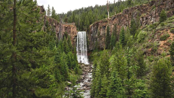
18. Tumalo Falls
Distance: 6.4 miles
Type of Trail: Out & Back
Difficulty: Moderate
Elevation Gain: 557 ft
Other important info:
- Dogs are allowed
- There is a fee for this trail, pay $5 or display your NW Forest Pass
The Tumalo Falls Trail will take you along the beautiful Tumalo Creek, and it can get pretty busy. It is located near the Three Sisters Wilderness, and the falls are right there in front of you almost before you even start the trek.
The falls themselves are awe-inspiring, so much so that they are considered one of the top things to do in Oregon, so you want to go early to avoid massive crowds.


Most of the trail is up a slight incline, but only a gentle one, and you will traverse a path through pine and spruce forest, catching glimpses of the river along the way.
It really is one of the most picturesque Oregon waterfall hikes in the area, with the waterfalls along the route just an added bonus.
READ MORE: Tumalo Falls Hike and Bike Trail
19. Proxy Falls
Distance: 1.6 miles
Type of Trail: Loop
Difficulty: Moderate
Elevation Gain: 164 ft
Other important info:
- Dogs are allowed
- There is a fee for this trail, pay $5 or display your NW Forest Pass
For those looking for a quick, gentle stroll in the beauty of Central Oregon, Proxy Falls Loop Trail has you covered. No matter your skill level, you’ll be able to enjoy this beautiful hike, which includes several waterfalls along the way.

The loop starts to the southwest of the parking lot, and the first section is a little rocky as you are walking through lava flow, which is pretty cool in itself. As you get closer to the falls, the lava flow turns to lush forest.
When the trail splits, you can choose to head down to Lower Proxy Falls or continue on the loop to Upper Proxy Falls. The path down is quite eroded, but there is an excellent viewpoint of the lower falls from the top of the trail.

Head back up to the main trail where it is only a short walk to Upper Proxy Falls, which spills beautifully down into a large grotto. You can then head back to the path and finish the loop.
READ MORE: Proxy Falls Hike
20. Toketee Falls
Distance: 0.8 miles
Type of Trail: Out & Back
Difficulty: Moderate
Elevation Gain: 170 ft
Other important info:
- Dogs are allowed
- There is no fee for this trail
With a beautiful flow all year round, Toketee Falls is a magnificent central Oregon waterfall hike.
The waterfall is best known for its columnar basalt formation, which frames the two-stepped, 113-foot falls carved by the North Umpqua River.

Although this is a short hike, be aware that it involves nearly 200 steps, ending at a viewing platform overlooking the falls. For most of the way, you will be passing through the stunning old-growth forest.
The word Toketee means graceful and pretty, which is precisely what you will experience when standing on the viewpoint.
RELATED: Guide to Umpqua National Forest: Waterfall Hikes & Hot Springs
21. Salt Creek Falls Trail
Distance: 0.6 miles
Type of Trail: Out & Back
Difficulty: Moderate
Elevation Gain: 223 ft
Other important info:
- Dogs are allowed
- There is a fee for this trail, pay $5 or display your NW Forest Pass
Salt Creek Falls is a large waterfall on Oregon’s coast, at 286 feet tall it is the second tallest single drop waterfall in Oregon. They are one of the state’s most powerful falls, with an average flow of 50,000 gallons a minute.

Two viewpoints will give you a great view of the cascading water. The first is a short walk from the parking area along a paved trail, and then down a steep slope for a full-on view of the falls.
The second will take you around the Salt Creek Falls Trail, taking you along the creek and through the forest near the upper lip of the falls.
READ MORE: Salt Creek Falls & Diamond Creek Falls Hike
22. Paulina Falls
Distance: 0.5 miles
Type of Trail: Out & Back
Difficulty: Moderate
Elevation Gain: 118 ft
Other important info:
- Dogs are allowed
- There is a fee for this trail, pay $5 or display your NW Forest Pass
- This area is subject to seasonal weather closures
For such a small hike, the reward is enormous. Towering Paulina Falls is located in the Newberry National Volcanic Monument and is one of the most accessible falls in the area—you can hear them from the parking lot.

However, if you hike a little further, there is so much more to discover.
The hike to the main viewing area is just a gentle stroll away along a paved path. From the main viewing point, you can hike down to the lower viewpoint, putting you in the perfect position for a dramatic photo opportunity.

If you still want to go further, you could take the loop trail of Paulina Creek Falls Trail or continue hiking along the Peter Skene Ogden Trail, where you can see even more waterfalls like McKay Falls.
RELATED: 10 Waterfalls Near Bend, Oregon That Are Worth Visiting
23. Sahalie and Koosah Falls
Distance: 2.9 miles
Type of Trail: Loop
Difficulty: Moderate
Elevation Gain: 364 ft
Other important info:
- Dogs are allowed
- There is no fee for this trail
Here’s another great 2-for-1 Oregon waterfall hike.
Although Sahalie is bigger, standing at 100 feet compared to Koosah’s 70 feet, both are well worth seeing, especially as this hike is straightforward to reach them.


You will be able to see both of the falls after just a short stroll from the parking lot, and then if you fancy stretching your legs a little more, carry on with the rest of the 2-mile trek, which will connect you to the McKenzie River National Recreation Trail.
Both Sahalie and Koosah Falls are beautiful and gushing no matter what time of year you visit. Don’t forget to visit the nearby Blue Pool.
READ MORE: Exploring the Sahalie and Koosah Falls Hiking Loop
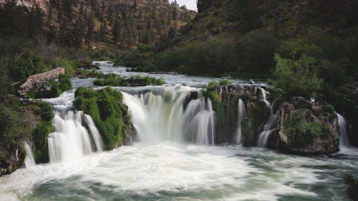
24. White River Falls
Distance: 0.8 miles
Type of Trail: Out & Back
Difficulty: Moderate
Elevation Gain: 170 ft
Other important info:
- Dogs are allowed
- There is no fee for this trail
- The trail is open year-round, but the parking lot closes in the winter
For a short and sweet Oregon waterfall hike, make your way to White River Falls State Park. The park and trail are named for the thundering falls here—a magnificent two-tiered beast.


Although it’s less than a mile in length, the trail is somewhat steep and offers little shade, which makes it a moderate trek, especially in the summer sun.
Once you reach the falls, you can cool off in the pool below the waterfall, or continue to the lower falls, which are usually less crowded.
25. Bar Creek and Mill Creek Falls
Distance: 1.5 miles
Type of Trail: Out & Back
Difficulty: Easy
Elevation Gain: 213 ft
Other important info:
- Dogs are allowed
- There is no fee for this trail
Check out the Bar Creek and Mill Creek Falls on this short and easy trail near Prospect. Although not as popular as some of the better-known Oregon waterfall hikes, this is one you won’t want to skip.
Both falls are around 200 feet and sit less than a quarter mile away from one another. The entire trail is just 1.5 miles long and can easily be tackled by hikers of all skill levels.


For a closer look, you can head onto a spur trail that leads to the base of Mill Creek Falls. Once there, you can play on massive boulders, sunbathe, or take a dip in the chilly Rogue River.
Places to Stay in Central Oregon
Campgrounds: La Pine State Park, Tumalo State Park Campground
Eastern Oregon Waterfall Hikes
The east of Oregon doesn’t attract as many tourists as the rest of the state, but believe us, there’s plenty here worth seeing.
The landscape here is truly unique, from surreal deserts to snowcapped mountains, with tiny towns dotted throughout.
- 29 Awesome Things To Do on an Eastern Oregon Road Trip
- Your Guide to Exploring The Painted Hills
- Exploring The Owyhee Canyonlands: Hiking, Rafting, & Camping
26. BC Falls
Distance: 2.6 miles
Type of Trail: Out and Back
Difficulty: Easy
Elevation Gain: 680 ft
Other important info:
- Dogs are allowed
- There is a fee for this trail, pay $5 or display your NW Forest Pass
BC Falls, which is located near Wallowa State Park, is a short trail, perfect for inexperienced hikers or families who want to experience the beauty of the area.
There is a lot to see in just under 3 miles, including the falls, stunning views of Wallowa Lake, and two different rivers.

The trail starts on the Chief Joseph Trail and follows the right fork after about a quarter of a mile. As you head down the river, you will come across several spectacular overlooks until you reach the point where BC Creek merges with West Fork to create a great waterfall.
RELATED: Guide to Visiting Wallowa Lake State Park—Adventures and Camping
27. Strawberry Falls
Distance: 6.9 miles
Type of Trail: Out and Back
Difficulty: Moderate
Elevation Gain: 1,368 ft
Other important info:
- Dogs are allowed
- There is a fee for this trail, pay $5 or display your NW Forest Pass
- The road leading to the trailhead is subject to seasonal weather closures
This beautiful 50-foot waterfall can be reached by following the Strawberry Basin Trail, a beautiful Oregon waterfall hike that goes both below and above the waterfall.

It is by far the most popular hike in Strawberry Mountain Wilderness, meaning on summer weekends, it can be pretty busy, but you will soon see why.
As well as the waterfall, the hike takes in two stunning mountain lakes, plenty of wildflowers, and an alpine meadow. You’ll head out from the Strawberry Basin Trailhead, following a path through stunning forests.

The waterfall is about 3/4 miles after Strawberry Lake, and you don’t need to complete the entire trail to see the falls. However, if you continue, you’ll be rewarded with Little Strawberry Lake at the end with a stunning view of the Strawberry Mountain Wilderness.
RELATED: Guide to The Strawberry Mountain Wilderness & Strawberry Falls
Places to Stay in Eastern Oregon
Campgrounds: Wallowa Lake State Park, Alvord Desert
RELATED: 29 Awesome Things to Do on an Eastern Oregon Road Trip
Tips For Your Waterfall Hikes in Oregon
- Do keep in mind many of these hikes will require a Northwest Forest pass, don’t forget to display it!
- Hiking shoes are always recommended, as most paths will have mud, rocks, or steep areas.
- Don’t forget that areas near the coast and Portland will often have gloomy or rainy weather, so prepping before with a light rain jacket on hand could be a good idea.
- For any photographer friends out there, don’t forget those lens cloths as conditions will be misty around the falls, grab that tripod, and try to aim your visits on a day with overcast to avoid sun splotches.
- Offline maps are always helpful, many of these falls won’t have cell service so download maps to have handy.
We hope you loved our list of Oregon waterfall hikes!