4 Unforgettable Hidden Trails to Explore in Oregon
A curtain of marine fog rolls through the moss-draped spruce, muffling the distant boom of Pacific waves. Forty miles inland, the same morning sun strikes jagged basalt pinnacles above an alpine lake still fringed with late-season snow.
Meanwhile, east of the Cascades, desert air already shimmers over painted badlands that look more Martian than Northwestern. Oregon is a state defined by contrasts, and it’s no surprise that the well-known routes fill quickly.
Yet just a canyon, ridge, or back road away lie footpaths where you can still hear raven wingbeats and feel like an explorer. Oregon residents participated in nearly 275 million trail activities, with walking on local paths accounting for over 54% of all trail use in the state.
This guide highlights four hidden gems, offering a taste of the diverse landscapes that await when you venture off the beaten path.
Table of Contents
Smart Preparation for the Trail Less Traveled
Venturing onto these quieter trails requires self-sufficiency. With cell coverage often unreliable, navigation is non-negotiable.
Always carry a downloaded digital map on your phone and a physical map in a waterproof bag as a backup. Check weather and wildfire conditions right before you leave, particularly during the peak season from late June to October.
Beyond the essentials, seasoned hikers also plan for recovery after strenuous hikes. Preparing for post-trek comfort is as important as packing the right gear.
To support their body’s needs, many include aids like electrolyte mixes or natural botanical supplements, such as Feeling 7OH’s premium tablets, ensuring they’re ready for the next adventure.
| Warning/Important: Cell service is unreliable on these trails. Always carry both a downloaded digital map and a physical map in a waterproof bag. Your safety depends on being able to navigate offline. |
📍 GET THE ULTIMATE PNW MAP 🗺️
Get our curated list of the best adventures, things to do, and places to grab a brew loaded onto your maps with just two clicks!
✅ Waterfalls ✅ Hikes ✅ Viewpoints
✅ Craft breweries ✅ National Parks ✅ 1400+ Pins


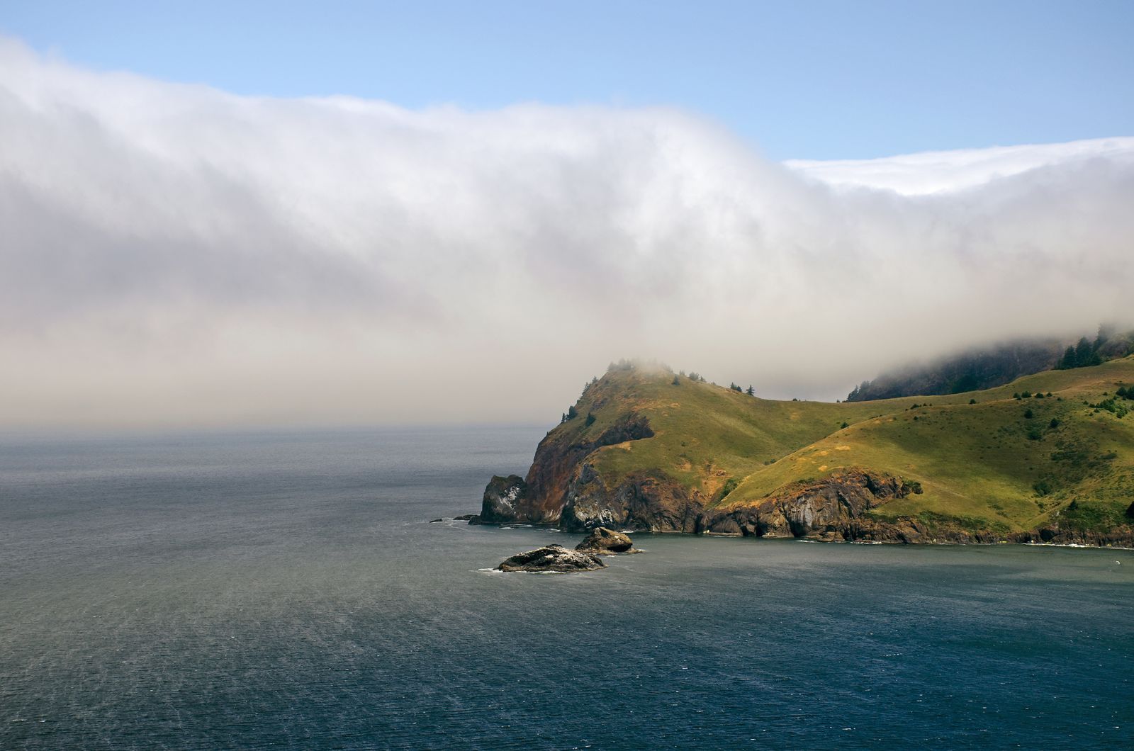
1. Cascade Head Rainforest Approach
Region: Coastal Range & Pacific Cliffs
Distance: 6.4 miles round-trip
Elevation Gain: 1,300 feet
Difficulty: Moderate
This trail offers a less-traveled path to the iconic views of Cascade Head, winding through a breathtaking old-growth Sitka spruce rainforest. The trail smells of salt and damp earth as it climbs steadily toward the grassy headland.
Time your summit for low tide to spot gray whales surfacing in the Salmon River estuary below. It’s a year-round destination, but be prepared for muddy sections and watch for frost-slick steps in winter.
NEARBY: 9 Things to Do in Cape Perpetua, Oregon
2. Jefferson Park via South Breitenbush
Region: Cascade Mountains & Alpine Lakes
Distance: 11.2 miles round-trip
Elevation Gain: 2,400 feet
Difficulty: Challenging
While Jefferson Park is a legendary alpine destination, this southern approach sees a fraction of the traffic of other routes. The demanding but rewarding climb delivers you to a stunning landscape of meadows and pristine lakes cradled beneath the glaciers of Mount Jefferson.
As part of the Willamette National Forest, which boasts nearly 1,700 miles of trails, a Central Cascades permit is required for this area, so plan accordingly.
From late July to early August, the meadows explode with lupine and red paintbrush, creating unparalleled alpine beauty. Snow can linger into July, so bring traction for your journey. Be prepared for mosquitoes early in the season as well.
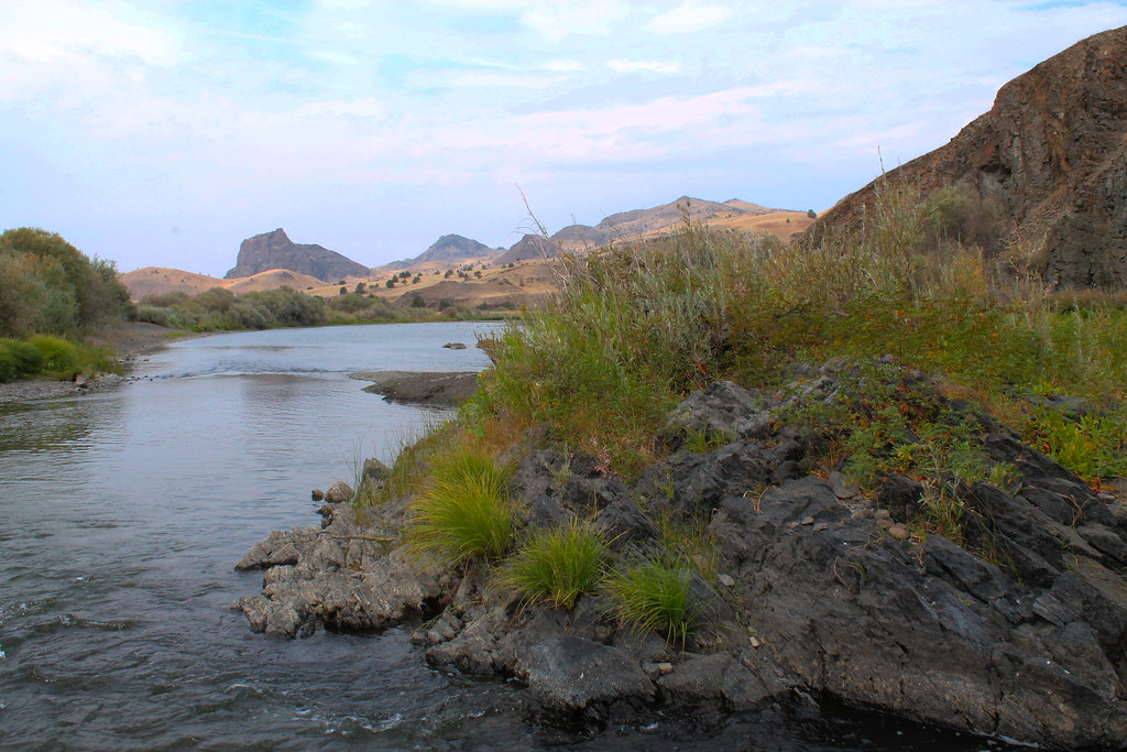
3. Sutton Mountain Summit Loop
Region: High Desert & Painted Hills
Distance: 7.3 miles round-trip
Elevation Gain: 1,900 feet
Difficulty: Moderate
Escape the crowds and discover the stark beauty of Oregon’s high desert on this panoramic loop. Best hiked from September through May to avoid intense summer heat, the trail traverses open ridges covered in sagebrush.
The summit offers sweeping 360-degree views of the John Day River basin and the distant Cascade peaks. Start pre-dawn in the warmer months and carry at least three liters of water per person.
| Pro Tip: To fully experience this designated dark sky sanctuary, plan to stay after sunset. The stargazing here is among the best in Oregon, offering an unforgettable finale to your hike. |
4. Illinois River: Indigo Creek Segment
Region: Southern Oregon & Rogue Wilderness
Distance: 10.8 miles round-trip
Elevation Gain: 2,300 feet
Difficulty: Challenging
Deep in the rugged Klamath-Siskiyou mountains, this section of the Illinois River Trail is a true wilderness experience. The path clings to canyon walls high above the emerald-green river, dipping into lush, mossy side-canyons.
This trail is a haven for solitude seekers but demands respect; poison oak is abundant, and Indigo Creek can run thigh-deep after heavy rains. The effort is repaid with dramatic scenery and a spectacular display of golden big-leaf maples in late October.
| Warning/Important: This trail demands respect. Be vigilant for abundant poison oak along the path and check conditions before you go, as Indigo Creek can become a dangerously deep crossing after heavy rain. |
🏨 Need a place to crash nearby?
From rustic cabins to boutique inns—check prices and availability in just a click.
The Path Forward
These four trails are just the beginning, representing the spirit of exploration that defines Oregon. This same spirit is embodied by the historic Oregon National Historic Trail, which spans approximately 2,000 miles across six states.
Pack smart, practice Leave No Trace principles, and prepare to discover a side of Oregon few get to see. The map is in your hands; may your trail be quiet and your views unforgettable.